Cargo Carriers SH33 at Charleston on May 5th 2017, wing tip strike on landing
Last Update: September 27, 2019 / 18:00:27 GMT/Zulu time
Incident Facts
Date of incident
May 5, 2017
Classification
Crash
Airline
Air Cargo Carriers
Flight number
2Q-1260
Departure
Louisville, United States
Destination
Charleston, United States
Aircraft Registration
N334AC
Aircraft Type
SHORT Sherpa
ICAO Type Designator
SH33
The airport reported it appeared one of the aircraft's wings hit the runway surface and the aircraft went off to the left of the runway into a hill. It was difficult to reach the aircraft, tail number N334AC, due to the steep terrain. The aircraft did not burst into flames.
The FAA reported the aircraft struck its left wing onto runway 05 and veered off the runway. The NTSB have opened an investigation.
The NTSB reported they are investigating the crash of a Short 330 at Charleston Airport. Six investigators plus support staff have been dispatched to Charleston.
Emergency Services reported, Barlow Drive (north of the aerodrome, left of and parallel to the runway) and Keystone Drive (short of runway 05) remaine closed.
Tower advised emergency services after issuing the crash alert, that the aircraft had hit runway 05 and the fuselage had gone off the left side of the runway. Emergency services reported debris on the runway. Emergency services were crossing runway 05 to access the crash site mainly via taxiway A3.
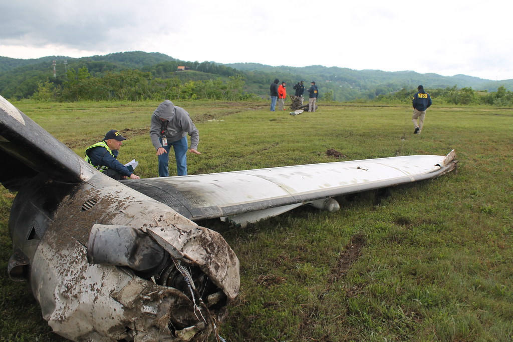
On May 6th 2017 the NTSB reported they have a surveillance video showing the crash and are currently examining the video. The main wreckage is about 25 yards down the hill, a couple of parts were on the grass on the side of the runway, there are witness marks and gouge marks on the runway where the aircraft struck the runway. According to preliminary information the aircraft was in a left bank at the time of first contact with the runway.
On May 6th 2017 noon the NTSB released the runway to the airport. The airport carried out the needed repairs due to the gouge marks and returned the runway to service.
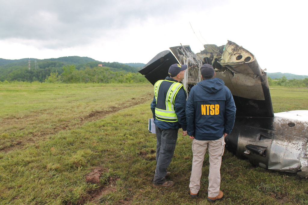
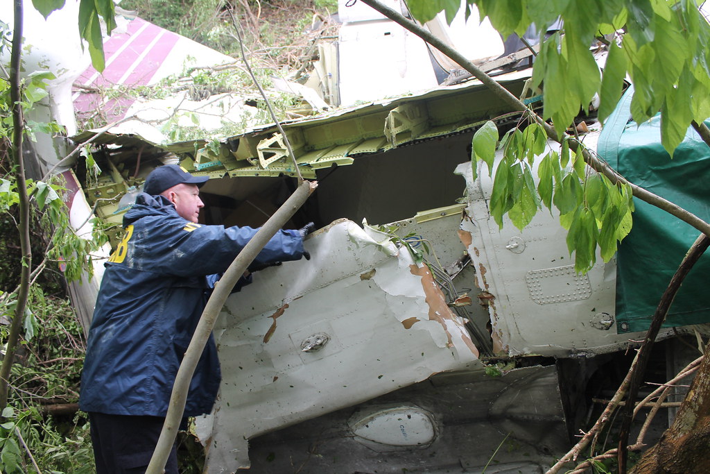
On May 6th 2017 afternoon the NTSB reported the aircraft impacted the runway about 340 feet past the runway threshold about 650 feet from the point of first impact at a heading of about 40 degrees off the point of impact, the main wreckage came to rest in the ravine off the runway about 100 feet below the runway on its left side, all parts except left wing and left gear are together, some parts of the stabilizer have broken off and are close to the fuselage, the right hand wing has folded over the aircraft. The left main wing and left main gear were removed from the runway, the runway was returned to the airport afterwards. All major components of the aircraft have been accounted for. The aircraft was not equipped with black boxes and was not required to carry cockpit voice or flight data recorders. Other electronic equipment is currently being checked for possibly stored data. The cargo has been off-loaded.
On May 7th 2017 Officials reported the male captain (47) and female first officer (31) have been identified. The families have been informed.
On Jun 5th 2018 surveillance videos were published, see below.
On Jun 5th 2018 the NTSB opened their investigation docket. The docket contains SMS text messages by the first officer that she exchanged with her friends, one snippet quite highlighting the atmosphere on the flight deck:
FO: 01/17/2017 23:24:56 Captain is sleeping. I'm gonna need you to keep me entertained for the rest of the flight
Friend: 01/17/2017 23:26:24 Wait wait wait. There's a pilot and a co pilot, and right now the pilot is asleep and the co pilot is texting. Is that accurate?
FO: 01/17/2017 23:27:09 Yes
The first officer hinted to her friends, that the captain - whom she had flown with earlier, too - was excellent in flying VFR, she had concerns however with his IFR flying skills.
A ground witness reported he saw the aircraft just below the clouds overflying him and thought the aircraft was on a VOR-A approach to runway 05. He only realized later that this had been the accident aircraft.
Th NTSB reported surveillance videos showed the aircraft in an unusual nose down attitude and a left bank while attempting to align with runway 05.
The NTSB also released a study/analysis of the video (see below) suggesting that the aircraft descended at 2309 feet per minute and 92 +/- 4 knots over ground, at the time of first contact with the runway the aircraft had a left bank angle of 42 degrees and a pitch angle of 14 degrees nose down. The cloud base was estimated at 683 feet +/- 60 feet based on the video.
On Sep 27th 2019 the NTSB released their final report concluding the probable cause of the accident was:
the flight crew's improper decision to conduct a circling approach contrary to the operator's standard operating procedures (SOP) and the captain's excessive descent rate and maneuvering during the approach, which led to inadvertent, uncontrolled contact with the ground.
Contributing to the accident was the operator's lack of a formal safety and oversight program to assess hazards and compliance with SOPs and to monitor pilots with previous performance issues.
The captain (47, ATPL, 4,368 hours total, 1,094 hours on type) was pilot flying, the first officer (33, CPL, 652 hours total, 333 hours on type) was pilot monitoring.
The NTSB described the sequence of events:
About 0642, the approach controller advised the flight crew that the airplane was 12 miles from HVQ and issued an instruction to cross the VOR at or above 3,000 ft (the minimum crossing altitude), then stated "cleared VOR-A approach runway 5." The first officer acknowledged this instruction. About 0646, the approach controller instructed the flight crew to contact the CRW tower controller, which the first officer acknowledged.
About 0646, the first officer contacted the CRW tower, initially stating that the flight was on a visual approach then corrected herself to indicate the VOR-A approach. The CRW tower controller acknowledged this transmission and provided wind information based on his direct readout display, indicating wind from 200º and speed of 5 knots, then cleared the flight to land Page 5 of 17 DCA17FA109 on runway 5. At 0646:55, the airplane crossed HVQ at an altitude of 2,900 feet msl and continued to descend.
At 0647:29, when the airplane was at 2,200 ft and about 11 miles from the runway, the CRW tower controller issued a low-altitude alert to the flight crew in response to an automated visual and aural alarm in the tower. The first officer responded that the airplane's altitude was showing 2,200 ft and that they were "getting down" to 1,600 ft, which was consistent with radar information (aircraft equipped with DME, such as the accident airplane, can descend to an MDA of 1,600 ft msl after crossing the second waypoint of the VOR-A approach, FOGAG; the airplane had not yet reached FOGAG at this time). The CRW tower controller responded that the alarm may have been falsely triggered by the airplane's descent rate, which the National Transportation Safety Board's (NTSB) radar performance study suggests was between 1,300 and 2,000 fpm. No further communications occurred between ATC and the accident flight crew.
At 0648:25, radar data indicated the airplane reached an altitude of 1,600 feet msl and leveled off about 2 miles before FOGAG. At 0650:18, radar data indicated the airplane began a descent from 1,600 ft at a calibrated airspeed of 124 knots about 0.5 mile west of the runway 5 displaced threshold. The NTSB's radar performance study of the accident flight calculated the airplane's descent rate about 2,500 ft per minute during the final approach to the runway. Nearby security cameras captured the airplane's final approach and descent to runway 5 as it emerged from the cloud bases about 1,600 ft msl. A ground eyewitness, also a pilot, corroborated that the airplane was "hugging the bases" less than a mile west of the airport.
The video and radar performance studies and witness marks on the runway indicate the airplane crossed over the runway 5 centerline in a steep left bank up to 42º. The descent rate reduced to about 600 fpm just before impact. At 0650:47, the airplane impacted the runway 5 centerline in a 22º left bank and 5º nose-down attitude with indications of increasing pitch, at an airspeed of about 92 knots, and on a north-northeasterly heading.
Video information and witness marks were consistent with the airplane's left wingtip striking the pavement first, followed by the left main landing gear and left propeller. The fuselage impacted the pavement and the left wing separated from the airplane during the impact sequence. The airplane slid off the left side of the runway through the grass safety area and down a hill through trees, coming to rest about 380 feet left of the runway centerline and 85 ft below the runway elevation.
The NTSB reported: "The airplane was not equipped with a CVR or flight data recorder nor was it required to be. None of the numerous PEDs recovered from the airplane contained relevant flight, voice, or video data from the accident flight."
Related NOTAM:
05/022 - AD AP CLSD. 05 MAY 11:28 2017 UNTIL 06 MAY 11:27 2017. CREATED: 05 MAY 11:28 2017
Metars:
KCRW 051254Z 20005KT 10SM SCT008 SCT070 SCT150 17/14 A2941 RMK AO2 SLP952 T01670139=
KCRW 051154Z 00000KT 10SM FEW000 SCT011 BKN060 16/14 A2942 RMK AO2 SLP956 FG FEW000 60024 70046 T01560144 10156 20139 55017=
KCRW 051144Z 20003KT 10SM FEW000 SCT011 BKN060 15/14 A2943 RMK AO2 FG FEW000 T01500139=
KCRW 051059Z 00000KT 10SM FEW001 OVC005 14/13 A2940 RMK AO2 T01440133=
KCRW 051054Z 23003KT 10SM FEW001 OVC005 14/13 A2941 RMK AO2 SLP952 VLY FG T01440133=
KCRW 051030Z 17004KT 10SM FEW001 OVC005 14/13 A2940 RMK AO2 VLY FG T01390133 $=
KCRW 050954Z 08011KT 10SM SCT007 BKN013 OVC031 14/13 A2938 RMK AO2 RAE46 PRESFR SLP943 P0001 T01390133 $=
KCRW 050946Z 06010KT 10SM SCT007 BKN013 OVC031 14/13 A2940 RMK AO2 RAE46 PRESFR P0001 T01390133 $=
KCRW 050854Z 13003KT 6SM -RA BR SCT004 BKN021 OVC048 14/13 A2947 RMK AO2 SLP974 VLY FG P0004 60023 T01390133 56013 $=
KCRW 050848Z 10003KT 6SM -RA BR SCT004 BKN021 OVC048 14/13 A2947 RMK AO2 VLY FG P0004 $=
KCRW 050754Z 07006KT 5SM RA BR FEW001 BKN048 OVC070 14/13 A2948 RMK AO2 SLP978 VLY FG P0016 T01440133 $=
KCRW 050703Z 07007KT 7SM RA FEW001 SCT031 OVC055 14/13 A2950 RMK AO2 VLY FG P0000 T01440133 $=
Aircraft Registration Data
Incident Facts
Date of incident
May 5, 2017
Classification
Crash
Airline
Air Cargo Carriers
Flight number
2Q-1260
Departure
Louisville, United States
Destination
Charleston, United States
Aircraft Registration
N334AC
Aircraft Type
SHORT Sherpa
ICAO Type Designator
SH33
Photos

This article is published under license from Avherald.com. © of text by Avherald.com.
Article source
You can read 2 more free articles without a subscription.
Subscribe now and continue reading without any limits!
Read unlimited articles and receive our daily update briefing. Gain better insights into what is happening in commercial aviation safety.
Send tip
Support AeroInside by sending a small tip amount.
Related articles
Cargo Carriers SH36 at Las Vegas on Jun 25th 2021, belly landing
An Air Cargo Carriers Shorts 360 on behalf of Fedex Federal Express, registration N970AA performing positioning flight SNC-700 from Las Vegas…
Cargo Carriers SH36 at Traverse City on Jul 17th 2019, bird strike
An Air Cargo Carriers Shorts SD-360, registration N367AC performing flight 2Q-1468 from Louisville,KY to Traverse Ciy,MI (USA), was on approach to…
Cargo Carrier SH36 at Louisville on Nov 6th 2018, nose gear collapse on landing
An Air Cargo Carrier Shorts SD-360, registration N367AC performing freight flight 2Q-1611 (dep Nov 5th) from Danville,IL to Louisville,KY (USA),…
Air Cargo Carrier SH36 at Houston on May 17th 2012, brakes fire at landing
An Air Cargo Carrier Shorts SD-360, registration N617FB performing freight flight SNC-1290 from Tupelo,MS to Houston Intercontinental,TX (USA) with 2…
Newest articles
") Fleet type match
Fleet type match
Porter E295 at Edmonton and Toronto on Feb 22nd 2026, passenger observed tyre separating on departure
A Porter Airlines Embraer ERJ-195-E2, registration C-GZQM performing flight PD-402 from Edmonton,AB to Toronto,ON (Canada) with 94 people on board,…
Calm AT72 at Arviat on Apr 25th 2026, runway excursion
A Calm Air Avions de Transport Regional ATR-72-212A, registration C-GREJ performing freight flight MO-488 from Thompson,MB to Arviat,NU (Canada) with…
Subscribe today
Are you researching aviation incidents? Get access to AeroInside Insights, unlimited read access and receive the daily newsletter.
Pick your plan and subscribePartner
ELITE Simulation Solutions is a leading global provider of Flight Simulation Training Devices, IFR training software as well as flight controls and related services. Find out more.
SafetyScan Pro provides streamlined access to thousands of aviation accident reports. Tailored for your safety management efforts. Book your demo today
AeroInside Blog
Popular aircraft
Airbus A320Boeing 737-800
Boeing 737-800 MAX
Popular airlines
American AirlinesUnited
Delta
Air Canada
Lufthansa
British Airways